The highest peak in North Africa, Jebel Toubkal (4167m/13,670ft), is usually the first goal of most High Atlas trekkers. In fact, during the season, approximately 90% of trekkers in the Atlas Mountains are likely to be in the Toubkal Region at any given time. Toubkal is easily accessible from Marrakech, and the summit can be reached in a couple of days, though more time for acclimatization is recommended. This is a stark but striking landscape. The views from Toubkal’s summit are spectacular, with the Atlas Mountains forming a spine that runs the length of Morocco, separating the gleaming Atlantic coast to the north and west from the scorching expanse of Saharan Africa to the south and east.
Jebel TOUBKAL ASCENT
The summit of Jebel Toubkal (4167m/13,670ft) is the goal of this short route. All hikers should be aware of the symptoms and dangers of altitude sickness, as well as the appropriate response. Because of Djebel Toubkal’s proximity to Marrakech and the possibility of a quick ascent to the summit, many trekkers ascend too quickly and suffer the consequences. If you do decide to take the route described here, try to avoid rushing straight from Imlil (1740m/5707ft) onwards, and instead spend the first night at Aroumd/Around (1960m/6428ft), which is only a short morning’s walk beyond Imlil.
Even from Aroumd to the Refuge du Toubkal (3207m/10,520ft), the trail involves a steady but demanding 1000m climb. This trek’s route description is set up as a two-day trek. Allow three days to include an overnight stay in either Imlil or Aroumd, or four if you want to spend a second night at Refuge du Toubkal after ascending the mountain, avoiding a strenuous walk back to Imlil on the same day.
QUICK LINKS TO HELP YOU SELECT A TRIP:
DJebel Toubkal Ascent Trek and Berber Villages
4 days Treks-Mount Toubkal
6 Days Toubkal Ciruit trek via Ifni lake
Toubkal round via Berber villages ” Azzaden valley ”
Toubkal 3 days from MarrakechMount Toubkal Ascent Express trek “2-days”
Day 1: Imlil – Aroumd/Around – Refuge du Toubkal – MT Toubkal Trek
• Net altitude change +1467m/4813ft
• Duration 5 hours 50 minutes
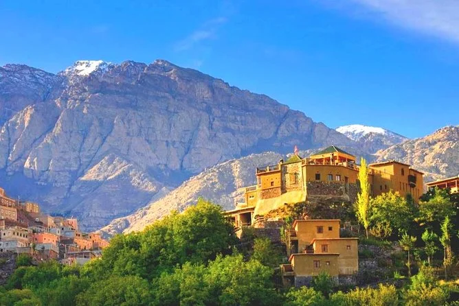
Walking south through Imlil, you’ll pass the Hotel Étoile du Toubkal on your right. After five minutes, just beyond Café les Amis, turn right onto a road that appears to be heading west towards Tizi Mezzik/Mzik. Indeed, just a little higher up, this road abruptly turns south and leads to Aroumd. As a result, it would be possible to simply follow this road to Aroumd. However, after only five minutes, turn left from the road on a right hairpin bend and instead follow the trail that leads through woodland, below the road, to Kasbah du Toubkal, which is reached in just ten minutes.
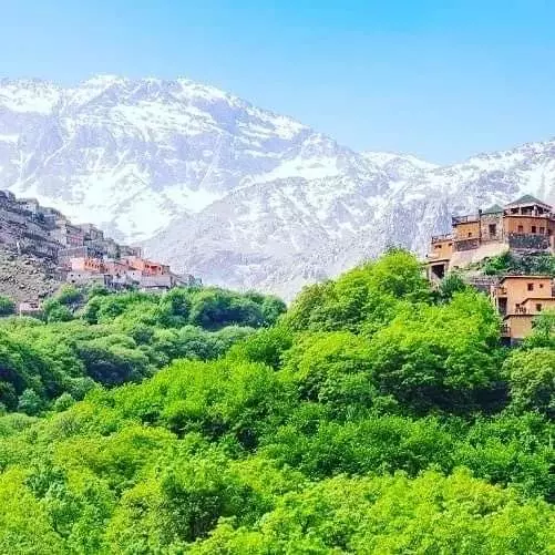
After leaving the Kasbah, the path crosses an irrigation channel and then climbs steeply in a series of zigzags along a mule trail to the right. Continue south for 25 minutes along the right (west) bank of the At Mizane Valley until you reach the village of Aroumd. At this point, descend steeply to the river and cross by bridge to the village on the valley’s far (east) side. If you’ve decided to spend your first night here to acclimate, you’ll probably want to explore the village.
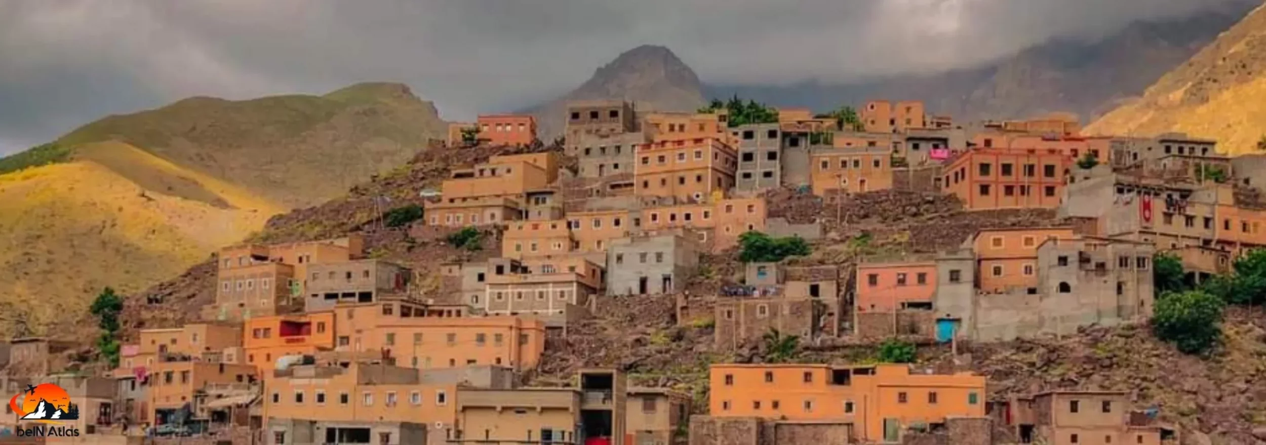
AROUMD/ARMED
Wind your way through its lanes behind the initial façade of a few newly built concrete houses to find a maze of traditional dwellings built on the hillside that form the heart of the old village. Aroumd has grown rapidly in recent years, with 60% of its 1600 residents working in tourism in some capacity.
Armed village
Pass a small walled orchard on your right as you leave Aroumd/Armed and pick up the trail along the left (eastern) edge of the river bed, which quickly opens out into a wide floodplain. The trail leaves the valley floor thirty minutes from the village, briefly climbing in zigzags to the left.
Follow the path past one small isolated shop selling soft drinks to another, neither of which is usually open before 10 a.m. However, do not assume that the nearby irrigation channel provides clean water because it simply siphons from the river flowing higher up in the main valley.
Follow the path for another 80 minutes, climbing steeply in places and enjoying beautiful views both up and down river. Then, after passing through a series of small waterfalls, return to the valley floor to cross the river near the marabout of Sidi Chamharouch (2310m/7579ft). It is possible to camp nearby, and very simple rooms are also available, though vacancies are unlikely in the summer, especially on weekends. There is no set cost. From the right (western) bank, a number of shops selling food and drinks, as well as carpets and other Berber artifacts, face the religious complex. Return to the trail and climb up the right bank behind the shops, away from both the river and the throng surrounding the marabout, to a solitary café set upon a magnificent natural terrace offering a bird’s eye view of the proceedings.
The path continues to climb gently to the south and south-west from the café. Before reaching another small café at Doudmet after about 60 minutes. Drinks can be found naturally cooling in water falling from a rock buttress here. The drinks and Berber artefacts can be purchased from an adjacent shop. The path is clear until 90 minutes. After Doudmet when the CAF Refuge du Toubkal comes into view. At which point you will need another 30 minutes to reach your goal for the day.
During your approach, you will pass through several flat areas that are suitable for camping. But if you do decide to pitch a tent, choose a sheltered spot if possible because the wind here can be very strong.
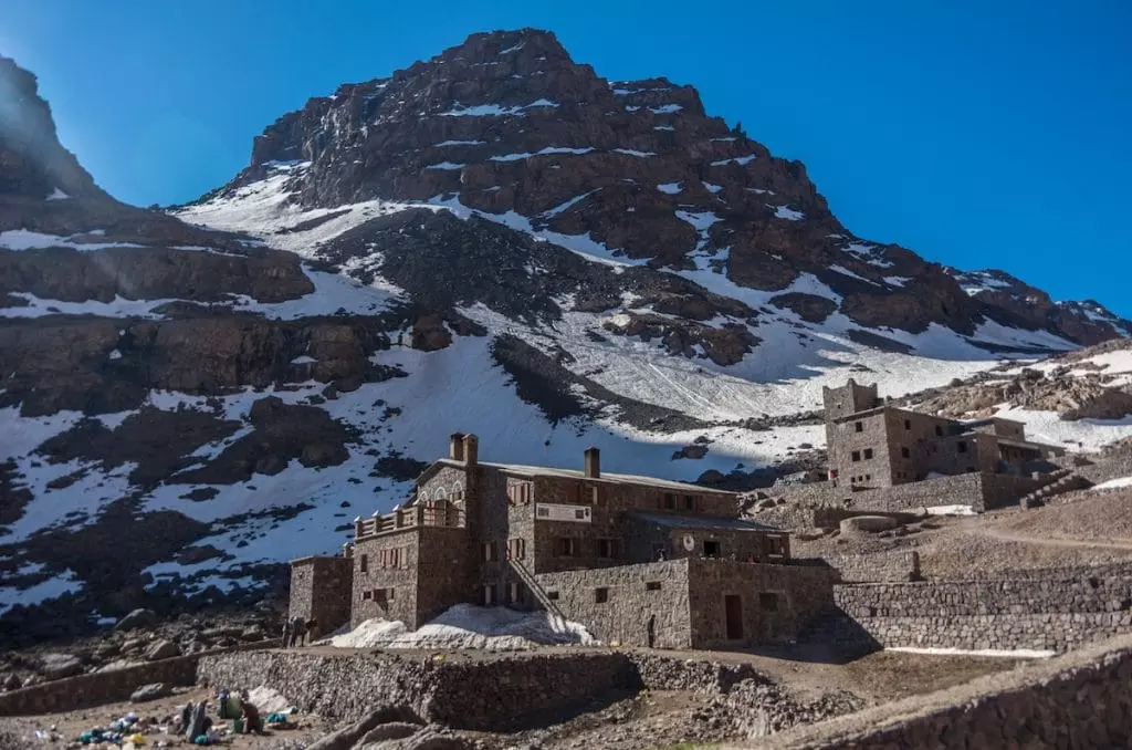
The long-established 90-bed, dormitory-style Refuge du Toubkal never closes but is often overcrowd, particularly on weekends. There is plenty of sheltered camping space on the refuge grounds for a small fee. Breakfast, lunch, and dinner are all available to everyone. The refuge has hot showers and a small shop selling cold drinks, including freshly squeezed orange juice, as well as other necessities, most notably chocolate. Registration is require upon arrival in both the Register d’hotel and the Fiche de nuitée refuge for all guests staying in the refuge, but not for campers.
The Neltner Refuge (now Refuge du Toubkal) stood alone in the valley below Jebel Toubkal for 70 years. However, new lodging, Moroccan-owned Les Mouflons, has recently been built alongside. Grilled windows and colored lanterns add atmosphere to the very clean and spacious accommodation, which was designed with Moroccan traditions in mind. There are also rooms for four, six, and eight people. Picnics and lunch can be provide. It is also possible to camp on the premises. Essentials are available in a well-stocke shop.
Day 2: Refuge du Toubkal – Jebel Toubkal summit – Imlil
Net achange ltitude -1467m/4813ft
Duration 9 hours
Many hikers start their ascent as early as 4 or 5 a.m. However, the afternoon storms in the Toubkal region that plague the ascent of Mgoun are usually absent. The goal of these trekkers is simply to reach the summit as early in the day as possible. If you do not want to be a part of their procession. Wait until around 7 a.m. When the mountain’s tranquillity is usually restore.
Look up into the large side valley entering the main valley from the east. This is the route you will take to the summit from the Refuge du Toubkal. To begin, head south from behind the refuge for five minutes. Following the small gully until you reach a small waterfall. To climb the scree path to the left, cross the stream in front of the waterfall (east). The path, which is occasionally obscure, scrambles over a swath of large boulders. The path is mark by small cairns, but at this point you just need to keep heading eastwards and upwards.
After 40 minutes, walk back over the top of a large and clearly visible rock overhang visible from the refuge to resume the climb. The path is now clearer, though it has degrade into rather difficult scree. It splits into three once it reaches the dominant cwm of the mountainside. Take the right-hand path because the others have the worst conditions and are more demanding. After another 90 minutes, the path swings to the left (north), just below a ridge that has been visible for some time.
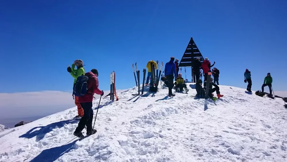
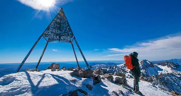
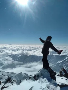
After another 15 minutes, you will see the summit, which is mark by a metal tripod. And you should arrive there in about 25 minutes. The views from the summit (4167m/13,670ft) are spectacular, albeit frequently hazy. Look for Jbel Sirwa, with its distinct volcanic plug, to the south. The less well-define Jbel Sarhro range to the south-east. For many, climbing Toubkal is a deeply spiritual experience. And you should not be surprise if you see a grateful trekker thanking Allah.
Allow 120 to 150 minutes for the descent back to the Toubkal Refuge, which follows the same route as the ascent. However, as you leave the summit, deviate briefly from the path to the north. If you didn’t notice the village behind you during your final ascent. You can now see Around ahead, to the north, and far below.
You may choose to spend an additional night at the refuge before returning to Imlil. Whether you do this on the same day or the next. You will need to retrace your steps back down the At Mizane Valley as far as Around. Which takes about 2 hours 40 minutes. Climb back up to Aroumd’s higher streets, then along the main lane heading north immediately below Gîte le Toubkal until you reach the village’s final house. The path begins to drop gradually at this point. First passing a small souvenir stall to the left before curving around to the right as small terraces appear ahead. The path continues to descend, now more steeply, winding. Through mature trees before leveling out and crossing Assif n’Imserdene. Which enters from the right 30 minutes after leaving the last house.
It continues through more trees on the far (north) bank, passes through Tagadirt, crosses another small river (dry in spring). And rejoins the piste in Targa Imoula. Take the path that leads left (west) from the village association center. Through a few houses and more trees, until it rejoins the main road that leads out of Imlil towards Tamatert. Follow the road to the left (west) down into Imlil’s center. Which can be reach in 30 minutes from the river.